About Mapit GIS - Map Data Collector
Mapit is a professional, stand-alone, cost effective mapping and surveying tool designed to enhance productivity while you are out there in the field. The app supports common file formats for input and output and is...
Mapit is a professional, stand-alone, cost effective mapping and surveying tool designed to enhance productivity while you are out there in the field.
The app supports common file formats for input and output and is capable to work with number of external GNSS receivers so you can get a centimetre level accuracy when you need to.
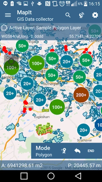
Design your survey forms, organize data on layers, work offline with mbtiles base-maps, access WMS services, use GPS tracking to capture your line and polygon features, record GNSS metadata and much more to discover.
The app is widely used by professionals around the world and can be easily adopted for different applications from agriculture and forestry to road construction, geology, land surveying and solar panel solutions. Personalized settings and flexibility makes this app fit for purpose tool which will enhance your surveying workflow.
App can be also used as a measurement tool to calculate areas or distances.
When saving location simply choose required attributes from predefined drop-down list, no need to type the same information over and over again. Import long list of attributes from text files and re-use them in number of projects. If necessary you can add pictures to each location as well.
If you are working in the field, gathering large amount of spatial data this app is designed for you.
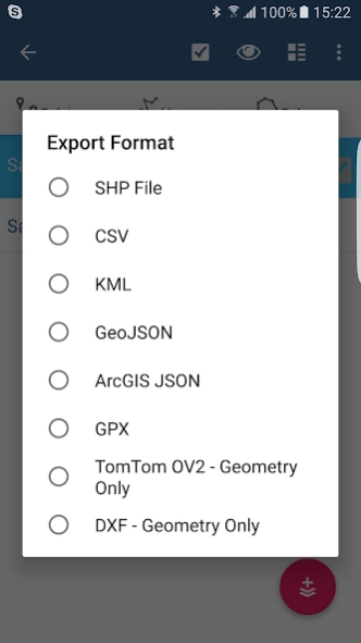
Speed up your workflow and make the data collection more efficient. Take advantage of survey layers and possibility to re-use same set of attributes for multiple surveys. Export your data to common GIS formats like Esri shapefiles, CSV, KML, geojson, DXF, GPX and post process your data using Desktop GIS software like qGIS.
Support for number of predefined coordinate systems and customised EPSG codes if required.
Mobile Data Collection Features:
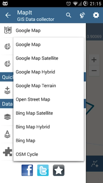
- Base maps: Popular online maps selections and offline mbtiles,
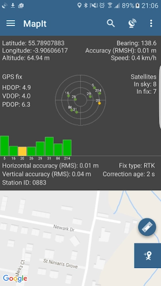
- Support for RTK corrected coordinates when external Bluetooth GPS / GNSS is connected,
- Support for WMS and GIS Server Tiled map services - load topographic and orthophoto maps, geological surveys, cadastral information and number of other services.
- Possibility to create and maintain sets of attributes - these are available as a drop down lists when new feature is being recorded, long lists of values can be imported from text files.
- Clusters for point map markers, efficient way of having large number of points on the map without performance issues,
- Currently 4 methods of collection are supported (GPS / GNSS location, map cursor location, tracking, point projection using angle and distance),
- Possibility to group your data into the survey layers - each survey layer may have a default set of attributes.
- Local SD card or remote export. At the moment shapefiles, KML, CSV, geojson, GPX and DXF export is supported,
- Direct export to Dropbox or FTP location
- Possibility to record multiple points, lines and polygons on one layer,
- When creating new polygon or line features measurement details like area or length are also available.
- GPS / GNSS and satellites status,
- Address, location search,
- Import point, line and polygon features into layer from CSV, KML, shapefile or geojson file,
- Backup management,
- Import/Export attributes from file and much more to discover...
Our users are successfully using Mapit in number of applications including:
- Environmental and woodland surveys,
- Forestry planning and woodland management,
- Agriculture and soil classifications and sampling,
- Road constructions,
- Land surveying,
- Solar panels applications,
- Roofing and fencing,
- Tree surveys,
- GPS and GNSS surveying,
- Site surveying
- Snow removal
Do not hesitate to contact us directly or using the contact form on our website.
Previous Versions
Here you can find the changelog of Mapit GIS - Map Data Collector since it was posted on our website on 2016-10-30 13:02:55.
The latest version is 7.8.0.0C and it was updated on 2024-04-22 12:38:47. See below the changes in each version.
Mapit GIS - Map Data Collector version 7.8.0.0Core
Updated At: 2021-08-16
Changes: FIX: Issue with Accuracy as HRMS reading. When connected to external GNSS this function was not working as expected.
FIX: Accuracy was always exported as HRMS when HRMS was available which was not expected behaviour.
FIX: Other minor bug fixes.
Mapit GIS - Map Data Collector version 7.6.0.0Core
Updated At: 2020-11-14
Changes: CHANGE: Target Android SDK 29
CHANGE: GPS location tracking running as foreground service.
CHANGE: Upgrade to Android Billing v3
FIX: In some configurations antenna height was not properly deducted from original height provided by GNSS receiver.
FIX: Some WMS were not properly displayed.
Mapit GIS - Map Data Collector version 7.5.3Core
Updated At: 2020-09-15
Changes: HOTFIX: Problem on some Android 9 and 10 devices. The application was hanging, crashing or not responding after 14th of September 2020.
Mapit GIS - Map Data Collector version 7.5.2Core
Updated At: 2020-07-12
Changes: FIX: Resolved problem with Dropbox import on Android 10.
Mapit GIS - Map Data Collector version 7.5.1Core
Updated At: 2020-07-09
Changes: CHANGE: Removed unused libraries dependency.
FIX: Minor bug removed related to application settings.
Mapit GIS - Map Data Collector version 7.5.0Core
Updated At: 2020-06-18
Changes: ADD: Romanian Translation
ADD: Support for PT08 Portugal geoid
Mapit GIS - Map Data Collector version 7.2.5Core
Updated At: 2019-11-15
Changes: ADD: Support for British National Grid Reference in search facility - you can search now for e.g. NT 34229 32184
CHANGE: Improvements for NMEA parser and improved support for EGNOS and Galileo.
Mapit GIS - Map Data Collector version 7.2.3Core
Updated At: 2019-07-09
Changes: HOTFIX: Export to Shapefile - on some devices the export was not working as expected.
HOTFIX: Barcode Scanner - on some devices was not working as expected.
Mapit GIS - Map Data Collector version 5.8.6
Updated At: 2018-01-31
Changes: Option to add multi selection field to the form.
Possibility to set the field as 'Required'.
WMS - Multiple selection allowed.
WMS, ESRI, Other Services - Transparency can be set for each service separately now.
WMS, WFS - Drawing order can be now changed.
Added support for Simplified Chinese.
Minor bugs removed.
Mapit GIS - Map Data Collector version 4.3.0
Updated At: 2016-10-28
Changes: ADD: Direct export of layers to SHP Files.,Changelog: http://mapit-gis.com/changelog